Land Surveying Intro Template
Create a compelling first impression! Customize our Land Surveying Intro Template to showcase your expertise—streamlined, professional, and ready to captivate clients in minutes.

80 results found for "Land Surveying Intro Template"
Videos
Images
Travel Vlog Intro
Travel Vlog Intro
#capcuthq#semuabisa#intro
CINEMATIC TEASER
CINEMATIC TEASER
#trailer #trailerfilm #cinematic #trend #fyp
travel vlog intro
travel vlog intro
#yt_templates#travel#intro#youtube#vlog
COMING SOON
COMING SOON
#comingsoon #openingtemplate #openingvideos #trailer
Travel Intro
Travel Intro
Travel Intro Use For Your Vlog #yt_templates#travel
youtube intro
youtube intro
#youtubetemplate#introyoutube
original series
original series
#videotemplates #teaser #comingsoon #intro #trailer
COMING SOON
COMING SOON
#openingvideo #trailer #comingsoon #intro #cinematic
Opening cinematic
Opening cinematic
#opening #intro #cinematic #minivlog #travel
Teaser Coming Soon
Teaser Coming Soon
#comingsoon #aestahatic #fyp #cinematic
Template Kind Channel Intro Minimalist Style Youtube Ads
Template Kind Channel Intro Minimalist Style Youtube Ads
Template Kind,Minimalist Style,Channel Intro, 5 Clips ,Make Better Ads With Our Template Now!
Youtube Intro Template, Fashion Theme, Minimalist Style
Youtube Intro Template, Fashion Theme, Minimalist Style
#fashion #fashionstyle #intro #introyoutube
Coming soon
Coming soon
#coming #comingsoon #opening #openingvlog #protemplate
intro plane 6
intro plane 6
#intro #plane #openingvideo #6
Channel Intro General Retro style YouTube Template
Channel Intro General Retro style YouTube Template
General industry, Channel Intro, Welcome to my channel, Retro style, Vintage, YouTube, Video template
Podcast Intro
Podcast Intro
#protemplatetrends#yt_templates #youtubeintro#intro#fyp
Intro video travel
Intro video travel
#intro #opening #cinematic #travel #transition
COMING SOON
COMING SOON
#comingsoon #opening #intro #openingvideo #protrend
News Media Industry News Intro Template
News Media Industry News Intro Template
#news #newstemplate #breakingnews
Coming Soon
Coming Soon
#comingsoon#trailer#movie#opening#intro
COMING SOON OPENING
COMING SOON OPENING
#comingsoon#staytuned#opening#nvidiacapcut#protemplatei
Cinematic Trailer
Cinematic Trailer
#capcutsealeague#opening#trailer#comingsoon#usa
Intro Template Gaming Intro Neon Style YouTube Video
Intro Template Gaming Intro Neon Style YouTube Video
Intro, Gaming, Gaming Intro, Channel, Neon.
Documentary intro
Documentary intro
#documentary#filipino#fyp#film#project#intro
COMING soon
COMING soon
#comingsoon #opening #trailer #openingvideo #protrend
Product Review Intro
Product Review Intro
#yt_templates #reviewproduct#gamingtemplate#trendgaming
Beige Vintage Scrapbook Style Youtube Intro
Beige Vintage Scrapbook Style Youtube Intro
Intro, Youtube, Beige, Vintage, Scrapbook Style, Make Better Ads With Our Template Now !
Intro Logo Template Black and White
Intro Logo Template Black and White
Intro, Logo Template, Minimalist Style
Intro Aesthetic
Intro Aesthetic
#fyp#intro#merdekaps#capcuthq
Opening / Intro Vlog
Opening / Intro Vlog
#everydayvlog#opening#openingvlog#intro#introvlog
Intro / Opening Vlog
Intro / Opening Vlog
#everydayvlog#opening#intro#introvlog#openingvlog
Company Logo Intro Display Template
Company Logo Intro Display Template
Logo Templates,PNG lmages, Intro, Company Promotional. Use Our Customized Templates To Easily Create Advertising Videos!
Intro youtube
Intro youtube
#protemplates #intro #yt_templates #youtube #travel
Technology Style Intro Template
Technology Style Intro Template
Intro, Semi-Open, Business Template, Technology, ad video with our cutommizable template #capcutforbusiness
COMING SOON OPENING
COMING SOON OPENING
#comingsoon #trailer #intro #cinematic #short
Office moment
Office moment
#oktoberdump2025 #minivlog #cinematic #office #fyp
Travel Intro
Travel Intro
#yt_templates #intro #introyoutube #ytintro #travelvlog
Logo Intro Template
Logo Intro Template
Logo Intro Template, Holographic Background, General Industry, Beauty Brand Intro, Creative Logo Reveal, Customizable Logo, Replace With Your Logo, PNG or JPEG Ready, Logo Text
Historical Intro
Historical Intro
#Historical #historicallandmark#Rizal #Movie
Youtube Intro Template, Travel Theme, Minimalist Style
Youtube Intro Template, Travel Theme, Minimalist Style
#travel #travelvideo #intro #introyoutube

All the Smart Tools You Need to Streamline Your Content Creation

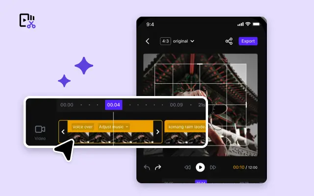
Video Editor
A powerful all-in-one video editing tool packed with features.

Sales Poster
Effortlessly create AI-powered promotional posters for your products.

Smart Crop
Crop videos to perfectly fit any platform's aspect ratio.
Custom Avatar
Create your own unique digital avatar for a personalized touch.

Image Editor
Your go-to tool for creating and editing images with ease.
Quick Cut
Speed up video editing by transcribing and editing directly from text.

Remove Background
Instantly remove backgrounds from images with one click.
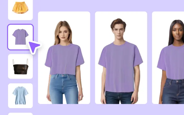
AI Model
Showcase your clothing on AI models for an immersive try-on experience.
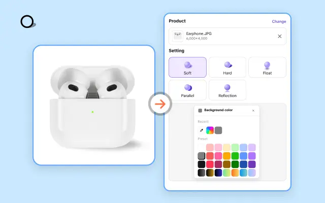
AI Shadows
Add lifelike shadows and lighting to products for enhanced realism.
About Land Surveying Intro Template
Do you want to present your land surveying projects in the best light possible? Whether you're creating proposals, showcasing completed surveys, or preparing reports, a strong visual presentation makes all the difference. With Pippit's Land Surveying Intro Templates, you can elevate the way you share your expertise and data. Forget bland, cluttered layouts—make a lasting impression with polished and professional designs that are as accurate as the surveys you conduct.
Pippit understands the unique needs of land surveyors and their clients. That's why our carefully curated intro templates are designed to highlight your project details, GPS coordinates, mapping snapshots, and essential findings in an organized and attractive way. Plus, our templates are completely customizable, offering flexibility for you to tailor colors, fonts, graphics, and text fields to suit your style or brand. Even if you're new to design, Pippit's intuitive drag-and-drop editing features make the process quick and frustration-free. Get ready to turn complex data into clear, compelling presentations in minutes.
Whether you're introducing environmental studies, boundary assessments, construction plans, or terrain mapping, Pippit empowers you to create intros that convey precision and professionalism. Beyond presenting your findings, our templates ensure your information is accessible and easy to understand—promoting stronger communication with clients, stakeholders, and partners. By adopting Pippit’s templates, you’re not just presenting data; you’re building credibility, enhancing your reputation, and simplifying workflows for everyone involved.
Start turning your land surveying expertise into standout presentations—try Pippit for free today. Explore our diverse range of Land Surveying Intro Templates and experience how effortless it can be to produce impactful and visually stunning content. Capture attention, earn trust, and take your surveying business to the next level with Pippit!


